
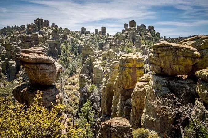
America has a new national park, and most travelers have never heard of it. On Oct. 20, President Donald Trump signed the Chiricahua National Park Act, turning a 102-year-old national monument in southeastern Arizona into Chiricahua National Park. It is the country's 64th national park and the first new one in six years (KOLD News 13).
If you are wondering whether the new title changes anything for visitors, the short answer is: not much yet. The land, the trails and the famous rock spires are exactly where they were last month. What will likely change is how many people show up. Here is what Chiricahua National Park offers, what the designation does and does not do, and how to plan a trip that avoids the most common mistakes.
What Happened and Why It Matters
The Chiricahua National Park Act passed Congress with bipartisan support in early October. Republican Rep. Juan Ciscomani, whose district includes the site, sponsored the House bill, and Arizona's two Democratic senators, Mark Kelly and Ruben Gallego, backed it in the Senate. Kelly first introduced a bill to create the park in 2021.
The change makes Chiricahua National Park Arizona's fourth national park, joining Grand Canyon, Petrified Forest and Saguaro. The last site to earn the title was New River Gorge in West Virginia, which became a national park under a 2020 law.
Why does a name change matter? Both national monuments and national parks are run by the National Park Service, so day-to-day management does not automatically change. The difference is visibility. "National park" is the label travelers search for, plan road trips around and check off bucket lists. Leaders in nearby Willcox, a town of about 3,500 people, are counting on that. Mayor Greg Hancock has said more visitors could mean more customers for local hotels, restaurants and small businesses.
What Makes Chiricahua Different
Chiricahua National Park is famous for hundreds of rock pinnacles, balanced boulders and spires packed into a compact mountain landscape. The rocks are the remains of a massive volcanic eruption that shook the region roughly 27 million years ago. Wind and water then carved the hardened ash into the formations visitors see today.
Early settlers called the area the "Wonderland of Rocks," and the site has long been described as the Land of Standing-Up Rocks. A few more facts worth knowing:
- Size: About 12,000 acres, or roughly 19 square miles, which places it among the smallest national parks in the country.
- Wilderness: About 85% of the land is designated wilderness.
- History: President Calvin Coolidge made it a national monument in 1924, and President Franklin D. Roosevelt expanded it in 1938.
- Heritage: The land lies within the historical territory of the Chiricahua Apache.
- Crowds: It currently draws roughly 60,000 to 70,000 visitors a year, a small fraction of what Arizona's best-known parks see.
What Changes Now, and What Doesn't
|
Stays the same |
May change over time |
|---|---|
|
Park boundaries and acreage |
Signs and branding, which officials say come first |
|
Trails, scenic drive, campground and visitor center |
Water systems and other maintenance projects |
|
Management by the National Park Service |
Visitor numbers, which officials expect to rise |
|
Protected tribal access for ceremonies |
Staffing and budgets, which have not been announced |
Interior Secretary Doug Burgum said the first order of business is updating signage to reflect the new name, followed by new water systems and other maintenance work. He also said visitation is expected to climb, and that staffing, infrastructure and programming will need to keep pace.
For Chiricahua National Park, that last point is an open question. Park Service officials have declined to say whether they will add staff, and the agency has faced significant workforce cuts. If visitor numbers jump before resources do, expect busier trailheads and parking lots, especially on spring weekends.
The law also protects access for tribal members to use the land for traditional ceremonies, and it allows temporary public closures of some areas to protect those uses. The specifics have not yet been decided. If you encounter a closure, respect it.
How to Visit Chiricahua National Park
Getting there. Chiricahua National Park sits in Cochise County, about 36 miles southeast of Willcox and roughly a two-hour drive from Tucson. There is only one entrance. The paved road climbs into the mountains and ends at Massai Point; it does not continue through to the other side.
Cost. As a national monument, Chiricahua did not charge an entrance fee, according to the National Park Service. Check the park's official page before you go in case fee policies change under the new designation. Camping at Bonita Canyon Campground carries a separate fee and is reserved through Recreation.gov.
Hours and road conditions. Chiricahua National Park is open 24 hours a day. However, the 8-mile Bonita Canyon Drive can close beyond the campground during hazardous conditions, such as winter snow and ice, fallen rocks, or flooding and debris after summer monsoon storms.
Parking. The Echo Canyon lot, the main jumping-off point for the most popular hikes, has only 19 spaces and a 24-foot vehicle length limit. It can fill quickly in February, March, April and on holiday weekends. When it does, start from the Massai Point or Sugarloaf lots instead.
Water. Drinking water is available at the visitor center and Faraway Ranch. Carry more than you think you need on any hike.
Pick a Hike by the Time You Have
|
Time available |
Suggested hike |
Distance |
|---|---|---|
|
30 minutes |
Massai Point Nature Trail |
About 0.5 mile loop |
|
About 1 hour |
Echo Canyon Grottoes |
0.8 mile round trip |
|
Half day |
Echo Canyon Loop |
3.3 miles |
|
Most of a day |
Echo Canyon or Massai Point to the visitor center via Heart of Rocks |
7.3 miles one way; arrange a ride back |
The Natural Bridge Trail, which starts along Bonita Canyon Drive, is another option at 2.4 miles one way.
A Sample One-Day Plan
This is a suggested itinerary, not a firsthand trip report.
- Early morning: Arrive at opening light and drive Bonita Canyon Drive straight to Massai Point for the panoramic view and the short nature trail.
- Midmorning: Head down to the Echo Canyon trailhead and hike the 3.3-mile loop before the lot fills and the day warms up.
- Afternoon: Picnic in the Faraway area and refill water before exploring the lower canyon.
- Evening: Camp at Bonita Canyon (if you reserved a site) or drive to Willcox for a hotel and dinner.
Common Mistakes to Avoid at Chiricahua National Park
- Assuming the road goes through. It dead-ends at Massai Point, so plan to exit the way you came.
- Arriving late on a spring weekend. The Echo Canyon lot is small and fills early.
- Ignoring the season. Summer monsoon storms and winter ice can close the scenic drive.
- Underpacking water. Water is available at only a few points in Chiricahua National Park.
- Expecting instant upgrades. New facilities and staffing, if they come, will take time.
The Bottom Line
Chiricahua National Park is the same quiet, rock-studded landscape it was last month, now with a name that will put it on far more travel lists. If you want to see it before the crowds catch on, this fall and winter may be the best window. Check the Park Service's alerts for road closures before you leave, reserve your campsite early, and get to the trailhead first thing in the morning.
Planning a shorter trip this season? See our guide to short fall getaways and how to plan one.